


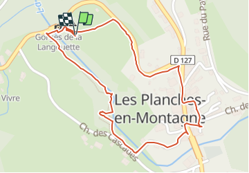
Boucle de la Langouette

rigol05
User

Length
1.4 km

Max alt
728 m

Uphill gradient
28 m
Km-Effort
1.7 km

Min alt
696 m

Downhill gradient
27 m
Boucle
Yes
Creation date :
2021-10-15 10:21:55.981
Updated on :
2021-10-15 10:21:55.981
--
Difficulty : Unknown

FREE GPS app for hiking
 SityTrail
IGN / Geographical institutes
SityTrail Plus
The world is yours!
About
Trail On foot of 1.4 km to be discovered at Bourgogne-Franche-Comté, Jura, Les Planches-en-Montagne. This trail is proposed by rigol05.
Positioning
Country:
France
Region :
Bourgogne-Franche-Comté
Department/Province :
Jura
Municipality :
Les Planches-en-Montagne
Location:
Unknown
Start:(Dec)
Start:(UTM)
270907 ; 5171263 (32T) N.
Comments